
Geology and Mineralization
The Archean Abitibi subprovince of Québec and Ontario is the largest greenstone belt in the world with an area of 700 by 300 km. The Abitibi Greenstone Belt is an east-trending volcano-sedimentary sequence intruded by plutonic suites that display evidence of arc evolution, arc–arc collision and arc fragmentation dating from 2,735 to 2,670 Ma. In the Thurston et al. (2008) scheme for the Abitibi greenstone belt, the Matagami volcanic rocks belong to the 2734–2724 Ma Deloro assemblage.
The Matagami district is subdivided in 2 main structural domains, North and South, separated by an important shear zone. This deformation zone has resulted in the major regional D2 deformation associated with the Opatica/Abitibi sub-provinces collisions. The North Domain is characterized by a stratigraphy and a structural grain of orientation E-W to ENE. The majority of the known volcanogenic massive sulphide (VMS) deposits of the district are spatially associated with extensive bands of felsic rocks within the South Domain that are divided into the North Flank, the South Flank and the West Camp. Regional metamorphism generally reached greenschist facies but locally amphibolite facies on the North Flank. The general volcanic stratigraphy of the South Doman is divided into the Watson Lake Group at the base, the Wabassee Group, and the Daniel Group at the top.
The Daniel Group, found within the Central Plain, is composed of mafic rocks varying from transitional to calc-alkaline basalt, with local calc-alkaline felsic units. The Wabassee Group, up to 3,000 m thick, mostly comprises massive or pillowed mafic lavas of basaltic and andesitic composition. However, local felsic units have been identified and are often linked to mineral deposits. The base of the Wabassee Group marks the end of the main hiatus in locally derived lavas. The Watson Lake Group is composed of two felsic units, a poorly exposed lower dacite (500 m thick minimum) and an upper rhyolite (1,500 m thick), termed the Watson Rhyolite. Both show good evidence of submarine volcanic textures. Conformably overlying the Watson Lake Formation is the Key Tuffite, a distinct horizon composed of laminated chert/tuff containing localized disseminated sulphides (pyrite, sphalerite, and chalcopyrite). It is a marker horizon that occurs over an extensive area within the Matagami Camp that represent a hiatus in the deposition of volcanic rocks. The Key Tuffite and most of the major deposits are located at the interface of the Watson Lake and Wabassee Groups. Some deposits are located near the base of the Wabassee group.
The massive sulphide deposits of the Matagami Camp are composed of medium to coarse-grained pyrite, sphalerite, and chalcopyrite with lesser pyrrhotite and associated magnetite. They are noted for their high zinc and copper grades with silver and gold as auxiliary components. The deposits demonstrate a variety of geometries that indicate deposition as exhalites on the sea floor through precipitation in platter/mound-shaped deposits, with sulphide pinnacles, and as precipitation of sulphides beneath the sea floor as roots within Pipe facies. Sulphides exhibit a wide variety of textures. These range from massive to very well banded with locally developed breccia textures, replacement and cross cutting features as well as stringers. Mineralization developed within Pipe alteration as a root of a keel structure can exhibit banding that is perpendicular to stratigraphy.

Mineral Holdings
The main Nuvau mineral holdings consists of 1,845 mineral claims which holds all past producing mines and all known undeveloped mineral deposits.
The historic mining areas are all located in the South Flank and North Flank of the Southern Domain. Historic mines Bell-Allard, Bell-Allard Sud, Matagami Lake, Orchan, Norita, Norita Est, Lac Garon, and Radiore 2 as well as the Orchan Ouest deposit can be accessed off the main highway 109. Historic mines Isle-Dieu, Perseverance, and New-Hosco can be accessed from the airport road that connects to the main 109 Highway near the Matagami Lake mine site.
The Caber, Caber Nord, and Phelps Dodge 1 deposits are located approximately 40 km west of the town of Matagami in the West Camp of the Southern Domain. The Phelps Dodge 1 deposit is accessible via a gravel access road that connects to the paved airport road near New-Hosco at the Nottaway Bridge. From the Phelps Dodge Road, a network of branched roads give access to the Caber, Caber Nord, Daniel and Phelps Dodge 2 – Cavelier deposits. The Caber and Caber North deposits are located approximately 4 km southwest from the Phelps Dodge Road access point. The Phelps Dodge 2 – Cavelier deposits, also within the West Camp, is located approximately 30 km southwest of the town of Matagami, west of the Allard River. The Daniel deposit, located in the Northern Domain, is located approximately 14 km north from the Nottaway Bridge.
The Lynx-Yellowknife deposits is located approximately 18 km southwest of the town of Matagami in the southern portion of the West Camp. The deposit is accessible via secondary roads that connect to Route 109.
Matagami-Dome
The Matagami-Dome claim block is situated approximately 18 km southwest of the town of Matagami in the townships of Galinée and La Gauchetière. The claims block is accessible via provincial Route 109 connecting Amos to Matagami. Near kilometre 205, a western leading gravel road gives access to many roads covering the claim block.
Caber
The Caber claim block lies 40 km west of the town of Matagami, in the townships of Gauchetière and Desmazures. From Matagami, it is accessible by travelling paved Route 109 and the airport road for 20 km, then the gravelled Phelps Dodge Road for 18 km. From there, a 4 km road leads to a network of branched roads that gives access to the claim block.
B6-20 McIvor
Also gaining access from the airport road and to the South via the Caber claims area, the B6-20 McIvor claims block is accessible by a north-south trending forestry road branching off from the airport road.
Samson
The Samson claim block is situated approximately 55 km west of the town of Matagami. The western and central portions of the claim block are accessible via a decommissioned road connecting the village of Joutel to the historic Selbaie mine as well as a network of winter roads. The eastern portion of the claim block, east of the Subercase River is accessible from the Matagami – Airport – Phelps Dodge Road and from there through a network of forestry logging roads that provide direct access to the property.

Exploration Potential
The property boasts of multiple VMS exploration targets, which have been identified over the past number of years. Key targets include, but are not limited to, Renaissance (VTEM1), Caber North, Orchan West, McLeod East, and McLeod Deep. These targets can be seen on the map below.

In addition to base metals, the property’s strategic location in the Abitibi region presents a high potential for gold mineralization, which has been largely overlooked due to the historic focus on base metals. The map below illustrates the property relative to known regional gold bearing features.
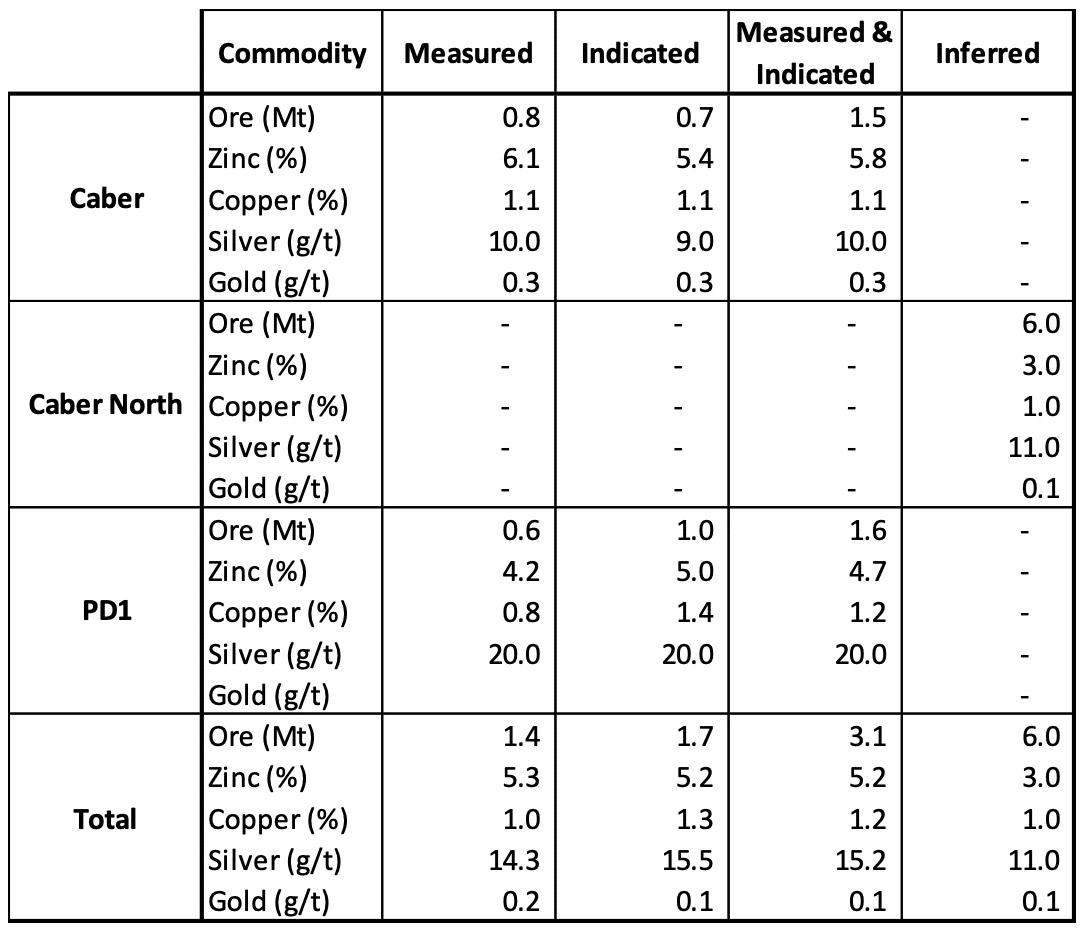
Resources
Nuvau is currently validating the defined resources of three deposits on the property – Caber, Caber North, and PD1. The resources were previously published by Glencore in 2021 and will be updated in Nuvau’s maiden technical report, expected to be completed by Q2 2023. The Glencore resource is shown in the table below.
Additionally, the company is evaluating the potential for unmined resources in the past producing mines on the property. Given that some of the highest-grade deposits were mined at a time when Zinc prices were lower, it is probable that there would be remaining resources. These mines will also be evaluated for further exploration potential and the possibility of adding additional resources.